Did you know that Western Colorado has its own version of Balanced Rock?
Like the famous Balanced Rock of the Front Range (located in Garden of the Gods), Miracle Rock, aka Potato Rock, is another large boulder with an incredibly small pedestal. However, unlike Balanced Rock, Miracle Rock is far less well known, far more remote, and is even taller.
L: Miracle Rock, near Glade Park (my photo.) R: Balanced Rock in Garden of the Gods (photo from Uncover Colorado.com)
Located southwest of Grand Junction, outside the tiny community of Glade Park, Miracle Rock is tucked away from civilization. The area is a popular local spot for field trips and picnics.
Located just a mile off 9.8 Road, the Miracle Rock Trailhead consists of a dirt lot, several picnic benches, and a vault toilet. The hike up to the rock is short, about 1-mile roundtrip. The route is initially hard to distinguish, as there is no signage. During my visit, I made my way down the middle between the picnic tables and past pinyon and juniper trees for a few yards. The trail then becomes easily visible and continues up a short but steep slope.
The so-called “potato” is perched on a ridge with a commanding view of the Little Dolores River Valley. While not as vivid a red as Balanced Rock, Miracle Rock is twice as tall as its Front Range cousin, rising 85 feet above its base. Weighing 12,000 tons, the rock is truly a miracle, perched on a sandstone base only 1 ft. wide. To make the situation more precarious, a solid crack runs the entire length of the pedestal. There is even a gap where you can see all the way through.
Miracle Rock appears ready to topple at any moment. However, as my fingers traced the many inscriptions on the rock, the monolith didn’t budge a bit.
Graffito or inscriptions? The oldest I found dated from 1928.
Just a few yards southeast of the boulder the ridgeline further continues. Located along the cliffside are beautiful alcoves.
Returning to Miracle Rock, I sat near the edge of the ridge and soaked in the solitude. The peaceful atmosphere up there is a great place to read a book, sketch, paint, or photograph the natural surroundings. As I visited later in the day, I watched the sun set as I returned to the trailhead.
I was the only individual up there my entire visit. Can’t say the same of Balanced Rock, which is a tourist attraction. If you’re looking for a short, quiet trek, visit Miracle Rock! I highly suggest going up there to watch the sunset, as I did. For more adventure, Little Dolores Falls is just 1.3 miles further down the road. Featuring natural swimming pools or “potholes,” this is a popular local spot to cool off in the summer. Caution: avoid the water during the spring or during thunderstorms as several fatalities have occurred due to strong currents. The next time I visit the area, I’ll visit Potholes and blog about it. 🙂
Map from Exploring Grand Junction: A Recreational Guide to West-Central Colorado by Glen D. Weaver
Getting There: To get to Miracle Rock Trailhead, drive up to Glade Park, which is located 16 miles southwest from Grand Junction. Glade Park can be reached by taking either Little Park Road, or Colorado National Monument’s Rim Rock Drive via the park’s east entrance. From Glade Park Store continue west on DS Road for 8 miles, then turn left onto 9.8 road. Continue for 1 mile and park at the trailhead.
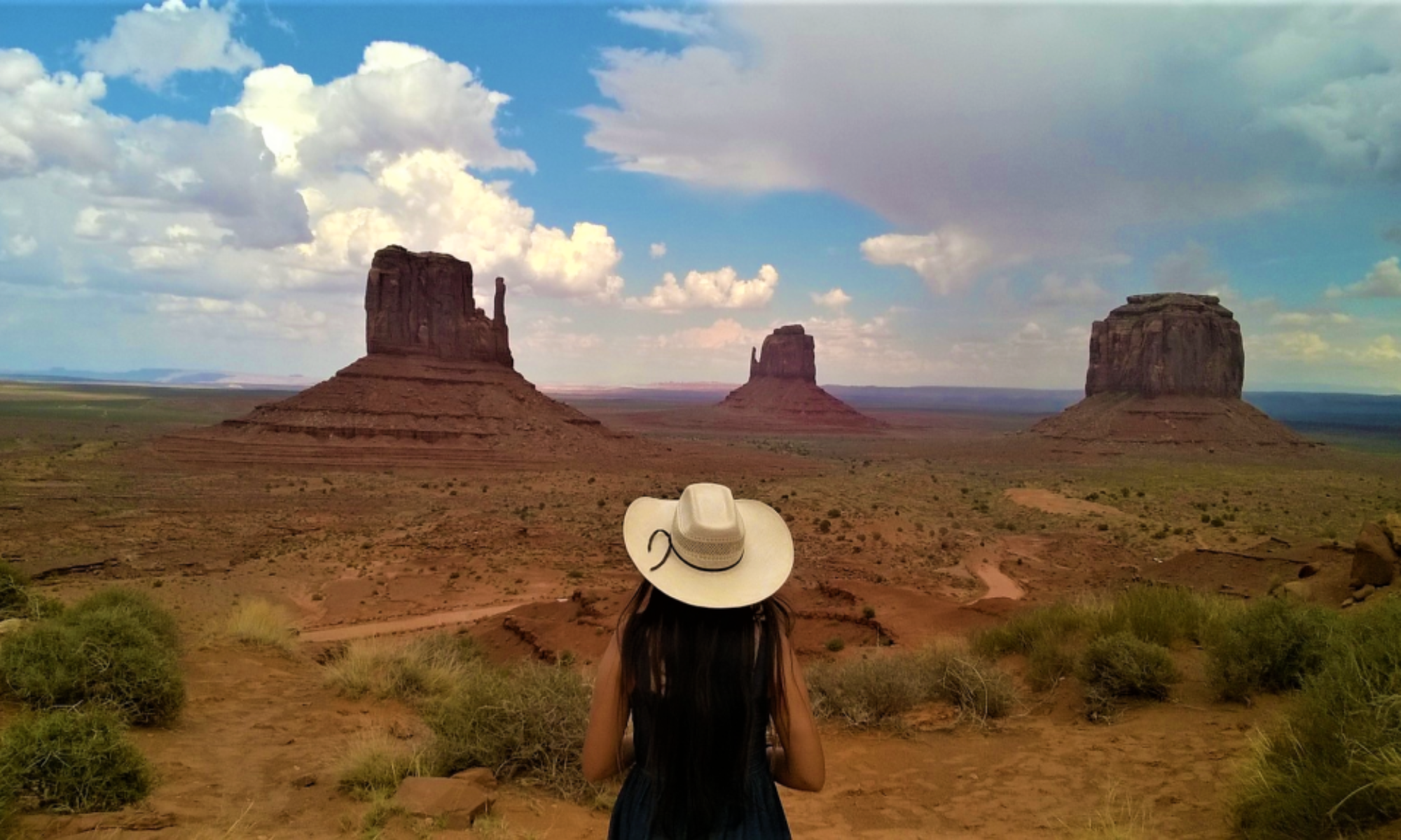
Looking for a hike that’s easily accessible and with incredible desert scenery? Lower Monument Canyon-Wedding Canyon Loop is just such a trek.
Located within Colorado National Monument just south of Grand Junction, Monument Canyon is home to Independence Monument, a tall monolith located at the end of Monument Canyon and Wedding Canyon.
Unlike other Colorado National Monument Trails that are accessible via Rim Rock Drive, you can access Lower Monument Trail and Wedding Canyon without being charged the park fee. Situated at the base of CNM, the Lower Monument Canyon Trail and Wedding Canyon trailhead is just off Broadway (HWY 340) and consists of a dirt parking lot, with two porta potties.
Starting at Lower Monument Canyon Trail
For my trek, I began with Lower Monument Canyon trail. The route begins in desert scrubland, winding up and past a Redlands subdivision, following the “buffalo fence.” Back in 1925, bison were introduced to the park, hence the fence. Bison are non-native to the high desert, so the National Park Service continuously provided hay and water for the creatures for the next six decades. In 1983, the remaining herd was finally relocated to Badlands National Park.
At .7 miles, the trail turns southward, revealing Monument Canyon and Independence Monument itself. You’ll come across a park register in a metal box, with hikers sporadically signing in.
Hewn into the red rock, the trail is well-marked and easy to follow as it gradually ascends. The canyon wall soars up immediately to your right. In several areas, there are stone steps carefully placed, but no real scrambling or path finding is involved.
As you hike, keep an eye out for desert bighorn. The area possesses several herds, and it’s a common sight to see several or more bighorn keeping a wary eye on adventurers from the cliff walls above.
Amazing Landmarks
The entire trek presents spectacular views, with sheer cliff faces and spires surrounding the trail. Turning around to face the mouth of the canyon, you’re rewarded with views of Grand Mesa (the world’s largest flat-topped mountain) in the east, while the town of Grand Junction sits in the Grand Valley below. Framed by the cliffs, this sight is a unique juxtaposition of nature and civilization.
As you further ascend the trail, Independence Monument grows in size, appearing taller than its actual 450 ft. height. The reason for this is the monolith itself is perched on a red dirt hill. Several unofficial trails thread around the base of the rock.
A unique fact about Independence Monument is every 4th of July rock climbers scale the monolith and place a US flag at the top. John Otto, founder of CNM, was the first person to climb the rock, and built many of CNM’s trails himself, including Monument Canyon.
Route Options
At this point, after soaking in the beauty and solitude of the area, you have several options: you can turn around to make for an out and back trek, hike Upper Monument trail all the way up to Rim Rock Drive, or continue into Wedding Canyon.
Upper Monument Canyon Trail skirts south along the base of spires and cliffs, offering different perspectives on Independence Monument and surroundings rock formations, such as Pipe Organ and Coke Ovens. I have yet to hike the rest of this portion, but have heard it’s a beautiful, steep route. Note: The route of Lower and Upper Monument Canyon trail is about 6 miles; roundtrip is 12 miles. If you want to hike the one-way route of 6 miles, arrange to have a car to shuttle you back to wherever you start. Locals recommend starting at Upper Monument and hiking down into Lower Monument.
Regarding Wedding Canyon, this trail branches off north from Monument Trail, at the base of the monolith. Descending into Wedding Canyon, this trail is so named as John Otto married Beatrice Farnham here in 1911.
Hiking with friends is the best!Your Read Run Writer second from left. 🙂Photo courtesy of Andrew K.
Upper Wedding Canyon
Unlike the grippy rock surfaces of Lower Independence Monument trail, the upper portion of Wedding Canyon Trail is “unimproved,” per the trailhead sign. This means the trail is mostly dirt and sand, and steeper. Even with my Salomon Speed Cross trail shoes with their prominent tread, I still felt some slippage underfoot. This is why it is usually recommended that if you’re hiking Lower Monument Canyon-Wedding Canyon loop, you start by ascending Wedding Canyon first.
However, should you hike the route vice-versa, as I have several times, trekking poles are especially helpful in descending Wedding Canyon. While the trail may be slick underfoot, the route is well marked throughout, with no trail finding involved.
The trail winds down and rounds the canyon’s edge before you return to the flatter base of CNM. There’s a few short hills on the way back as the trail meanders back to the Lower Monument Canyon trailhead.
Lower Monument and Wedding Canyon Trails: A Must See
Easy to get to with spectacular views, I highly recommend Lower Monument and Wedding Canyon trails. Popular with locals, this route is rarely crowded, even when the parking lot is full. Spring, fall, and winter are the best times to hike this loop. If you choose to hike during the summer, do so in the morning or evening, and bring plenty of water. Soak in the surroundings, and marvel at this corner of Colorado’s canyon country. With just enough imagination, you may be able to picture the bison that once roamed along the desert sands. 🙂
~LMC
Courtesy ofColorado National Monument Facebook page
On Saturday, September 5, my friend Christoph and I summited Mount of the Holy Cross.
Located at the northern most end of Colorado’s Sawatch Range, Holy Cross is renown for its snowy cross embedded on its eastern face. Made famous by photographer William Henry Jackson’s iconic 1873 photo, the peak drew pilgrims in the 1920s-30s.
William Henry Jackson’s famous photograph of Mount of the Holy Cross; the photo was taken from the summit of Notch Mountain. Image from Wikimedia Commons.
Sadly, the cross today is not as prominent as pictured in Jackson’s photos. But that fact doesn’t deter folks from climbing the mountain. Rising to 14,005 feet, Holy Cross is a proud Colorado “Fourteener.”
As with summiting any mountain, Christoph and I started hiking early, around 6:30 AM, to summit before any possible thunderstorms. This peak is notorious for its history of lost, injured, and missing hikers; located in Holy Cross Wilderness just southwest of Vail, the area is especially rugged and remote. North Ridge Route, rated Class 2 due to much rock hopping, is the standard route, and is 12 miles roundtrip with 5,600 ft. in total elevation gain. Note: The trailhead map labels this same route as Mount of the Holy Cross Trail, and the section from the trailhead to Half Moon Pass is also called Half Moon Trail. To any folks reading this who have not summited 14ers: I would NOT attempt this peak for your first 14er! This is a long, strenuous out and back trek. Even if you are very fit and/ or from CO, altitude sickness is a very real threat. People have died on Holy Cross, due to becoming lost/ injured or to exposure; don’t become a statistic.
Map at Half Moon Campground.
For this trip I packed 3L of water and a water bottle, along with several snacks. The longest hike I had done before this was 14ers Belford and Oxford, an 11 mile hike, in July 2013. Having bagged both those 14ers in one hike, I figured I could add Holy Cross to my list.
We arrived at the trailhead at 6:15 AM. As was the case, Half Moon Campground tends to fill up early, so we parked along the road a few yards down. Setting my Garmin to “Hike,” we maintained our goal pace of 2 miles/ hour for most of the route in. Winding SW/S, the trail starts well below tree line, at 10,370 ft. The sun had barely risen, and we rapidly gained elevation. At 1.5 miles we crested Half Moon Pass, elev. 11,600 ft., and alas, began descending—so much for all that elevation we had made. The trail descended back into the woods, but not before we caught our first glimpse of our goal, Mount of the Holy Cross.
Rising above all other peaks in the valley, Holy Cross is striking. The irony: for all its name and history, hikers don’t get to see the famed cross, as this route approaches the north, not the east, face of the mountain. To view the Cross, you must summit “13er” Notch Mountain, on the south side of Half Moon Pass.
Continuing on North Ridge Route, rapid switchbacks drop down 1,000 ft. into the forest, where we crossed East Cross Creek. The trail begins to climb again, then reaches tree line. From here the real climb starts: exposed and very steep. However, Colorado Fourteeners Initiative (CFI) did a great job creating steps out of the boulder field. From around 12,100 to 13,400 ft. we continued on these “stairs,” to the north ridge, marked with cairns. Turning left, and the final ascent looms above—so close! The trail fades, and for the last 300 feet you find your own way up over the talus.
At around 11:15 AM, we made it! Not a cloud in sight. About seven or eight others folks roamed the top, taking in the panorama of peaks: Ten Mile-Mosquito range to the east, Flattops to the northwest, Gore Range to the northeast, and the Elks to the south, with Maroon Bells and Capitol Peak visible.
We made it! I wish I had made a sign proclaiming our ascent…US Geological Survey marker at summit.Looking down from the east edge of the summit, with Bowl of Tears lake below.
As the forecast had promised, there were no thunderstorms this afternoon. The entire day was perfect: blue sky, cotton ball clouds, plenty of sunshine and no wind. With such pristine conditions, we were in no rush to descend. We agreed to much needed nap time on the peak: snoozing on a 14er is something both of have us have wanted to do. On the east edge of the top, we stretched out and soaked in the sun, marveling at the fast changing lone clouds above us. Eventually we dozed off for several minutes: sooo relaxing and restorative.
Nap on a 14er? Check.
With the weather utterly still and calm, we remained on the summit for nearly two hours. It was well past noon now, and several hikers took a cue from us, stretching out and snoozing at 14,000 ft. in the air. Per usual in the great outdoors, everyone we met was very kind, and for most of the day, we temporarily forgot about, well…2020. At the top of Holy Cross, everything felt normal.
Savoring the summit. The Elk Range is in the background.
After a few last summit pics, we began the long descent down, a little past 1 PM. As with my running, in hiking I am faster on the ascents than I am on descents; ironic, huh? So the way back down to tree line seemed to take forever; luckily my hiking buddy is very patient and encouraging! It was pretty toasty now on the northern ridge, nearly 80 degrees. I was now especially glad for my trekking poles, in helping me navigate my way down the talus and loose rock on the steep slopes. Note:Do not make the mistake of losing North Ridge Route by straying down into the valley below. There is a history of hikers getting lost/ stranded on the west talus slopes of the peak. Instead, you want to remain hiking along the ridge, sticking to the exact route that you hiked in.
The American pika, so adorable! Never have I seen, or heard, so many pikas as I did on this trek. Photo from www.nfw.org
My temples ached a little on the way down, so I increased my water intake, and we paused several times to listen the serenade of the “eep”ing pikas. 🙂 It was late afternoon by the time we reached tree line, and once we returned to East Cross Creek again, I made up for time on the climb back to Half Moon Pass, passing several folks on the way up.
View of Holy Cross from East Cross Creek.The remnants of Pilgrims Hut, by East Cross Creek.
My trusty hiking boots now bit into my toes on the downhill, and by the last few miles I was hobbling. Back in the woods, on the final descent back to the trailhead, it was refreshing to be finally out of the sun. We arrived at my Jeep at 7 PM; excluding our time on the summit, we had been on the trail for a total of 10 hours. 😀
My Garmin stats for the out and back portions of the hike.
Tired and dusty, we headed to Minturn (pop. 1,129), but as we guessed, Minturn had “turned in” for the night (sorry, couldn’t resist; however, this is hilarious after you’ve been hiking all day, haha). So to Vail we went for much deserved food, consuming a burrito each. Finally, we hit the road home. Mount of the Holy Cross: another 14er for the books, for each of us. 😀
Summit selfies.
Holy Cross, the “Mysterious Mountain,” unique for its snowy cross, history, and isolation, is a satisfying climb. However, it is not a trek for the faint of heart. The out and back route of 12 miles total is strenuous with over a mile of total elevation gain. Plan for a long day hike, or even better, spend the night at Half Moon Campground. If you are considering a 14er, I would attempt this particular peak only after you have summited several other 14ers. Bring plenty of water; stay hydrated the entire time. I finished my 3L bladder right at tree line on the hike down, with 4 miles to go, leaving me with a 16 oz water bottle and Gatorade. For me, Honeystinger chews and electrolyte powders definitely help fight off fatigue, and slather on lots of sunscreen (the sun was blazing the entire hike), and wear a hat. And when frustration and fatigue do creep in, just look around to spot the pika, and let their ever constant EEP! encourage you on your way. 🙂 For those wholly prepared for the journey, Holy Cross is more than rewarding for its beauty, isolation…and plenty of pikas, of course. 🙂
Until next time, little pikas!
Getting there: From Denver, take I-70 west 100 miles, passing through Vail, then take Exit 171. Take US 24 southward two miles, passing through the small town of Minturn. Continue almost three miles, then turn right onto Tigiwon Road. A well maintained dirt road that 2WD vehicles can easily access, continue zigzagging up for eight miles, arriving at Half Moon Campground. NOTE: Every year from November 22–June 21st, Tigiwon Road is closed to vehicles, but mt. biking and hiking are permitted.
After enjoying the first part of our summer Southwest Colorado trip in Cortez and Durango, my friends Jamie, Yoli, and I continued to the second part: exploring Hovenweep National Monument, the former mining community of Rico, and the small, beautiful town of Ridgway.
After our one night stay in Durango, we departed the Strater Hotel the following morning. Before we left, I made sure to inscribe a brief message in the aptly named Room Journal. A notebook in which guests describe their experiences at the Strater and overall travels, I enjoyed reading others’ accounts of their journeys passing through southwestern CO. 🙂
Heading To Hovenweep
A bright blue day, we headed back east on Highway 160, passing through Cortez again. We then headed north on Highway 491, the land wide and open: if it weren’t for the Abajos to the east and the San Juan Mountains to the west, you’d think you were in the Great Plains.
Jamie helped navigate as we made our way to Hovenweep National Monument, a park that “protects six prehistoric, Puebloan-era villages spread over a twenty-mile expanse of mesa tops and canyons along the Utah-Colorado border,” as described on nationalparks.org.
Indeed, Hovenweep really is in the middle of nowhere. From Highway 491, it is all too easy to miss the turn for Road BB, which winds west for several miles in near isolation. We then turned southwest onto Co. Road 10, all the while looking for the turnoff to the park, but we missed it and had crossed over into Utah without knowing it. Pulling off to the side, we reassessed our location, backtracked a few miles, and finally found the turnoff, CR 268 A.
Hovenweep: A Hidden Gem
The Visitor Center, just inside the Utah border, swung into view, and you know a park is truly remote when you observe just 2-3 other vehicles in the lot. Grabbing water, hats, and sunscreen, we stepped out into the glaring sunlight.
Several ruins are situated in Little Ruin Canyon, just outside the visitor center. A 1.6 mile path loops around the ruins, which consists of several walls, foundations, and towers. The most impressive ruin I found to be Hovenweep Castle, a sturdy edifice which does resemble a castle.
Views are stunning, as Sleeping Ute Mountain dominates the southern horizon, puffy clouds meandering across the skies. Approaching the park, the very top of Shiprock (not pictured), located just over the border in New Mexico, is visible as well.
As we walked along in the heat, I marveled at the silence of our surroundings: no cars, no hum of civilization. The entire area was serene and somewhat lonely; a stark contrast from when Hovenweep was a bustling agricultural community “[o]nce home to over 2,500 people” more than seven hundred years ago, according to nps.org.
We only saw five or so other folks during our walk, which was refreshing. If you are wanting to observe and enjoy Ancestral Puebloan ruins in solitude, then I highly recommend visiting Hovenweep. And the area we visited is just one section of the park: there is more to explore and see on both sides of the Colorado-Utah border.
Big sky country.
Walking at a leisurely pace, we completed the loop in about a half hour or so. I honestly wished we could’ve stayed longer: the isolation of the area, the ruins looming around, was so calming and peaceful. Yoli and Jamie, thank you ladies for recommending we visit this place!
My horse goes where I go!
Driving into the San Juans
Departing Hovenweep, we headed back to Cortez, so Yoli could pick up her car where she’d parked it at Stone Turtle cabins, where we’d stayed the first night of our trip. After I filled up my car and Yoli picked up her dogs, we headed north on Highway 145. Our destination was the tiny, former mining town of Rico. I was feeling sleepy from the heat, so Jamie was kind in driving for me. Cruising away from the desert and into the San Juans, the landscape of Highway 145 is utterly beautiful. Pinyon and juniper give way to cottonwoods and pines, as the road steadily climbs into the mountains.
After an hour or so of driving, Rico pulled into view, nestled in a narrow mountain valley. A silver mining camp in the past, the town was founded in 1879. Old storefronts and masoned buildings line the main street, and we parked along the road. Jamie and I ambled along the main road and the adjoining dirt side streets; Yoli arrived several minutes later and joined our walk.
Rico: A Glimpse into the Past
The sun blazed down, though it was noticeably cooler, the elevation being 8,825 ft . With a population of 266, Rico today is much “sleepier” than it was during its mining heyday: in 1892 the town’s population was 5,000. As I suspect, the 1893 Silver Crash “ended the bonanza times , though mining [in Rico] continued sporadically into the next century,” writes Philip Varney in his book Ghost Towns of Colorado.
Rico Court House
We observed several impressive brick buildings, all from the late 19th century. Some have been clearly restored and are in use, while other buildings are abandoned and locked up. For me, a girl who grew up “ghost towning” and fascinated with all things Victorian, Rico is a dream. It was Jamie’s suggestion we visit this lovely little town, so many thanks my friend!
Walking Around Ridgway
We continued on Highway 145 , before turning onto Highway 62 toward Ridgway. Just when I thought the views could not be more spectacular, I was wrong. We were now further up in the San Juans, hands down Colorado’s most striking mountains: red in color, jagged, and isolated. At one point, we slowed to a near stop as a herd of sheep grazed adjacent to the road. After driving more than an hour, we then began dropping down toward Ridgway.
If you love John Wayne, then you’re aware that the town (pop. 973) and environs served as filming locations for the 1969 classic True Grit. The town park and one boardwalk are featured in the film. Though we didn’t have the time to take a True Grit Walking Tour of the town, we passed by the True Grit Café (whenever I’m in the area next I’ll stop by for a bite to eat).
Walking around, the tiny town was abuzz with tourists and plenty of Jeepsters; I was all too happy to pull up alongside various Jeeps. Last year, I passed through Ridgway briefly on my way to hike Blue Lakes: if you love hiking, I highly recommended this trail. The San Juans do not disappoint.
After giving Yoli a hug, it was time to head back to Grand Junction. Heading north on Highway 550, the mountains receded and the desert emerged once again. The temperature warmed up again as we dropped in elevation. Jamie and I arrived back in town around 7:45 PM. After a bite to eat, we went for a walk, and observed a stunning Western Slope sunset: a fitting conclusion to our trip.
Southwest Colorado: A Spectacular Region and Great Trip
Southwest Colorado is spectacular: from jagged mountains to arid canyons to lush farm fields, this region is unlike any other in the Centennial State. For outdoor enthusiasts, history buffs, and those obsessed with the American West, I cannot recommend this place enough.
I am so grateful for embarking on this memorable summertime adventure with my friends! Jamie and Yoli, a big THANK YOU to both of you: from great live music to staying at unique places, you ladies made this trip not only lots of fun, but possible in the first place. I look to forward to future adventures with ya’ll! 🙂 Until next time,
~LMC
Shout out to singer-songwriter Elle King! We listened to this album, Shake the Spirit, several times during this trip. A wonderful blend of rock, country, and blues, a memorable soundtrack for our adventure. 🙂
This summer, my friends Jamie, Yoli, and I visited Southwest Colorado!
We departed Grand Junction on July 26th. The prior evening, I went along with Jamie and her family to see beloved country singer Gary Allen perform at Las Colonias Amphitheatre: thank you guys for having me tag along! 😀 We sat just a few rows away from the stage—VIP access—and it was a lively show: Allen is such a talented performer. I’m no country music aficionado, but damn, was I impressed: he can sing, play, and write. The crowd was more than appreciative, everyone standing and singing along the whole evening.
Cruising to Cortez, CO
The following morning Jamie and I departed in my Jeep, our destination Cortez, CO. We took Highway 50 south then took Highway 141 west towards Gateway. Driving up Unaweep Canyon never gets old; the upper reaches of the canyon are Colorado’s own Yosemite, the imposing granite cliffs soaring above you.
I’m familiar with Highway 141 up to the tiny community of Gateway, location of the prestigious Gateway Canyons Resort. Looping south, the drive was all new to me, as we drove along the Dolores River, following the striking red rock canyon carved by the river.
This area is incredibly beautiful and isolated. Along the edge of the canyon for several miles are the remains of the Hanging Flume, an open water chute constructed between 1888 and 1891. Sitting about 75 feet above the river, the flume channeled water to help facilitate operations at area placer mines. According to interpretive signs at the pull off, the flume was incredibly efficient, channeling over 23 million gallons of water in a 24 hour period. Wow.
Resuming our drive, we passed the former site of Uravan, an uranium mining town. Once a bustling community, the town was abandoned, eventually razed and declared a Superfund site, due to radioactive contamination.
Now well out of Dolores Canyon, we passed through the tiny community of Nucla, and continued on Highway 141. The land flattened out and for several miles resembled the sagebrush plateaus of Wyoming. As we drove further on, I recognized the Abajo Mountains to the east, just over the Utah border, and to the south, the striking profile of Sleeping Ute Mountain, near Cortez.
The view from the cabin looking south, just a few miles from Cortez.
Hello, Cortez
We arrived just outside of town in the mid-afternoon. Jamie had reserved one of the charming Stone Turtle cabins for us to spend the night. Situated in the middle of sprawling ranch and farmlands, this area is the definition of “big sky country.”
Looking out the north facing picture window at the back of the cabin, I observed ranch hands wrangling up cattle.
After unloading my car, Jamie and I headed to town to explore a bit. We parked along Main Street, and stopped by some shops. We visited the aptly named BOOKS, the building near to bursting with new and used volumes. Grabbing some groceries at City Market, we headed back to the cabin. By then Yoli had arrived from her trip to Arizona, having driven from Flagstaff. Shortly afterwards, Yoli’s friend Tisha joined us as well. After having dinner, we got ready to see the band Reckless Kelly perform at the Montezuma County Fairgrounds.
At the fairgrounds, the stage was set up in the arena, facing the stands. We watched the entire show while standing in the arena. Unfortunately I didn’t really document this evening, but the small snippet vid below gives you an idea of another fun, music filled evening. Reckless Kelly are a very talented, energetic band. It was a smaller crowd, but no less fun. Thank you Yoli for the tickets. 🙂
Great show!
Destination: Durango
The next morning we woke early to leave for Durango. After breakfast on the front porch, Tisha left for home, and the rest of us ladies hopped in my car to head east. Highway 160 is a scenic drive, the desert giving way to higher altitude and pine trees. We arrived in Durango in about an hour, and continued to Vallecito Reservoir.
Jamie navigated our way as we drove NE on CO Road 240 for 24 miles through dense ponderosa forest. When the lake came into view, we were stunned at just how big the lake is. Vallecito Reservoir is its own hidden world with plenty of boats, docks, and camping/ RV areas. Driving around the entire perimeter of the lake, I was amazed how much life there was: campers and boaters and cabins everywhere. Without a doubt, this lake merits its own weekend getaway in the future.
For this trip, we parked at Vallecito Creek Trailhead and began our trek. Heading north, the trail starts level and wanders adjacent to the Vallecito Campground. Rocky outcrops and TALL ponderosas border the trail. At about 1.5 miles in, the trail begins to ascend, following upstream the narrow canyon formed by Vallecito Creek.
We continued on, and at one point spotted a tiny, sandy beach along the water. The river churned past, and a pile of broken logs and debris on the shore attested to the strength of the rapids.
🙂
We hiked a few more miles, traversing through the forest. Per usual in Colorado, the summer thunderheads rolled in for a brief shower, and for a few minutes we remained under the cover of the pines. Soon the sky cleared, and we came upon one of the larger bridges, our turning point. Here we stopped for snack time and further admired the magnificent settings.
My trusty Salomon Speedcross 4 🙂 The perfect hiking shoe.Hi!
The Strater Hotel
After break time, we headed back the way we came. We arrived at the trail head around 5 PM, our hike totaling about 7.5-8 miles roundtrip: a perfect outdoor adventure. We arrived back in Durango about an hour later, destination the historic Strater Hotel.
Built 1887, the Strater is a premier example of Victorian architecture and interiors. From the handsome masonry to exquisite woodwork and intricate wallpaper, I felt transported to yester-century as soon as I entered the lobby. Our room was located on the first floor at the back of the building. It was a cozy space with fancy wall paper, and just outside the window ran the famous Durango and Silverton Railroad.
Downtown Durango
After freshening up post hike, we hit the town. We headed to Steamworks Brewing for dinner, where we sat facing the Hogback: beautiful view. Then we wandered along Main Street. Ever the book worm, I made sure to check out Maria’s Bookshop. Super cozy and welcoming, I know I could spend several hours there.
Spotted: David Roberts’ latest book, I look forward to reading this.
We had ice cream at Cream Bean Berry, then proceeded to Wild Horse Saloon, where we hung out for several hours. A live band played, and folks crowded the dance floor.
After several drinks, it was time to hit the hay. Days 1 and 2 of our Southwest CO trip: a success! The adventure continues in Part 2: Hovenweep, Rico, and Ridgway—stay tuned for that upcoming post!
Earlier this month my friend Chelsea and I summitted Grays Peak, one of Colorado’s most popular Fourteeners, or a mountain rising over 14,000 feet.
Colorado has anywhere from 52 to 58 such peaks, depending on who you ask. Certain criteria determine what constitutes as a 14er. Obviously, criteria #1 is a peak must exceed 14,000 feet…BUT a 14er point must also “rise at least 300 feet above the saddle that connects it to the nearest 14er peak (if another exists nearby),” according to www.colorado.com. Take your pick!
Hmmm, so how many 14ers are there really?
I’ve hiked several 14ers before—Bierstadt, Oxford and Belford, and the four mountains known collectively as DECAMERON—but it’s been a few years since I hiked my last one. Chelsea has climbed 14ers as well, and it was her suggestion we climb at least one this summer.
For anyone interested in climbing a 14er, know that you must summit well before noon, to avoid lightning from afternoon thunderstorms. Attempting a 14er entails being awake and on the road before the sun is up. For convenience and time, Chelsea and I chose the extremely popular Grays and Torreys peaks for their accessibility on I-70. Connected by a saddle, you can easily “bag” both mountains in a day; G and T are often the first 14ers for lots of folks. Categorized as Class 2 peaks, the main trail is steep but not technical, or entails no real climbing or scrambling. For those who have the experience and proper gear, jagged Kelso Ridge along the northeastern flank of Torreys is your option.
Chelsea and I arrived at the trailhead around 7 AM. Due to the peaks’ proximity to Denver and the Front Range urban corridor, G and T are heavily trafficked 14ers; don’t expect any true wilderness solitude. To avoid the thickest crowds, go on a week day if possible. Chelsea and I went on a Monday, and while there were plenty of folks, it was nothing like when I climbed Bierstadt (on a Saturday, to be fair), a never ending line of folks akin to a pilgrimage.
The Grays Peak National Recreation Trail is an out and back route, 8 miles round trip, with a 3000 ft. ascent. The trail starts just a little below tree line. From the trailhead the path winds southwest along a narrow alpine valley. No route finding is required due to the high traffic, and how visible the trail zig zags along the northeastern face of Grays. The trail gains altitude gradually for the first 2 miles or so, before the steeper ascent begins. Partially up Grays the trail forks, so you have the choice of summiting Torreys first, then crossing the .75 mile saddle to top Grays, or vice versa. Chelsea and I chose to ascend Grays.
The sun had not yet crested the mountains, but already a few folks who had summitted G and T passed us on their way back to the trailhead. Chelsea and I took our time, taking pics and just marveling at the scenery. For being such a popular trail, I was surprised, and relieved, by how pristine the surroundings looked; I didn’t observe any visible trash or vandalism.
Both of us having grown up in Colorado, being up at elevation normally doesn’t give us any problems. However, the affects of less oxygen the higher you go can lead to altitude sickness for some. Side effects: nausea, headache, mental disorientation, physical weakness, and in serious cases, swelling of the brain. Altitude sickness is fickle as some folks, with little acclimatization, can climb a 14er with no problem. Others, despite their fitness level or being a Colorado local, can fall ill. First off, be sure to bring plenty of water and snacks, wear sunscreen and a hat: at higher altitudes you dehydrate much faster. If you begin to feel the affects of altitude sickness, turning back is the best option. Listen to your body.
Can you spot the pika? 🙂
As we continued our climb, we saw and heard pikas, extremely adorable little mammals that are closely related to rabbits. As the trail became steeper, we viewed several mountain goats just off the trail. As neat as it is to see these animals up close, it is rather disheartening in how tame these creatures are, used to constant human presence in the area. No doubt some folks are feeding them, hence their entirely casual demeanor; they showed zero fear or aversion to us. 🙁 Sad. So much for wildlife being wild…
We gained the top of Grays around 10:30 AM. Throughout the ascent we kept a watchful eye on the atmosphere, for any hints of impending thunderstorms. Lucky for us, the sky was clear, save for solitary fast moving cottonball clouds.
Almost to the top! Soaking in those views. 🙂
As expected, views from a 14er never disappoint. Visible to the southeast is the unmistakable profile of fellow 14er Pikes Peak, while to the west one can just barely make out Mt. Holy Cross. They were several dozen folks on Grays’ mountaintop, taking pics and enjoying snacks. It was cool up top with a slight breeze but no gale force winds; I honestly thought it’d be much cooler. The night before I remembered to bring paper and sharpie, so I could write a sign for us to proclaim our summitting of 14, 270 ft. 🙂
We did it! It was after the climb I realized there is no apostrophe in Grays…Looking south from the top of Grays.Mt. Holy Cross is just right of center.My horse goes where I go!
After a few more minutes on the crest, we began our descent. We decided to save Torreys for another day, so we could hike along with more friends; another adventure to look forward to! 🙂 Descending was easy, the sky remained clear, and the sun had warmed the alpine valley below.
As Chelsea and approached the trailhead, I heard someone behind us calling my name. Turning around, I saw my cousin Nate and his friend running down the trail, having just climbed and descended Torreys via Kelso Ridge. I’d told Chelsea how my cousins Nate and Doug love to climb G and T and have done so multiple times…and sure enough, here was one of them. 🙂 Nate, it was great to see you!
Nice surprise! Bumped into my cuz Nate on the way back down the mountain.
In fact, it was Nate who took me snowshoeing in December 2016 up Forest Road 189, the dirt road that leads to the trailhead. We parked at the lot just off Highway exit 221, and winded our way a few miles up the snow packed road. Unlike summer, we only saw a few folks out. The views were incredible, and if you’re looking for solitude, winter is the time to go check out this area. If you were wondering: G and T can be summitted in winter IF you have the proper gear (i.e., ice axe, spikes) AND experience.
Old mining buildings on the road near the trailhead.
Chelsea and I arrived back at my car just before 1 PM, and for lunch we headed to Dillon. At Red Mountain Grill we both feasted on taco salads, before heading home. Sure, I felt a little tired, but honestly, afterwards I felt pretty good. I wasn’t exhausted at all, like I was after climbing Belford and Oxford. Running has certainly improved my endurance and lung capacity, so this 14er did not feel strenuous to me or Chelsea, who is quite the dedicated runner as well, and a true Colorado mountain girl. 🙂 For those interested in hiking their first 14er, I recommend Grays. The trail is well marked and no scrambling is involved. As stated earlier, you won’t find any true solitude at these peaks, but the views and experience are worth the trek. 🙂
Getting There: From Denver, head west on Interstate 70 for 53 miles, then take the Bakerville Exit, #221. A four mile dirt road, Forest Road 189, winds south to the trailhead. This road is pretty steep and especially rough on low clearance vehicles; I was glad I took my Jeep Wrangler. Parking at the trailhead fills up fast and early! I parked on the side of the road about a quarter mile from the main parking area. Some folks choose to park at the dirt lot just off the exit and hike in from there. The earlier you get there, the less hassle and less crowds.
Ochres, reds, yellow patchwork on the foothills. Immaculate blue sky. Too perfect. Orchestra of crickets every evening. Smoke tinged air. The winding down of the past verdant season. That strange, yet almost comforting in some sense, melancholy in the air. The days shorten, the shadows lengthen. Pumpkins appear, adorn porches. Break out the long sleeves, fleece jackets. But no need, certainly not this September, to retire shorts and tees. Summer still finds its hold in the afternoon heat.
Run up the foothills, observe the sharpness of color contrasts: evergreens amongst the gold aspens. Stroll along a creek, beneath the kingly canopy of ancient trees. A line from Edward Abbey, from his “Sonnet for Everett Ruess,” springs to mind:
“Gold coin of cottonwoods, the spangled shade…”
Could not be more true. Simple and concrete.
The hills have long since faded from emerald to honey. Fall, with the lower temps and dimming days, the prologue to winter, the guarantee of coming cold: warmth. This is what comes to mind. The warmth of the play of colors on nature’s grand stage. The cool, blue-gray tones are reserved for winter. For now, the last warmth stays. Indian summer. Fading daylight, cooler air makes chlorophyll break down. Horses transform from summer sleek to fall fuzzy. Nostalgia appears. I remember my horse, this time three years ago, as he stood at the tie rail just before the sun dipped. He was getting furrier for the coming winter. It was a quiet day at the barn, save for the cricket or two chirping in the creek side brush. I drank in the sight of him, so relaxed, peaceful. Ears forward, alert. His chestnut coat outlined in gold. A benevolent shaft of sunlight touching his face, his velvet nose. The only indication of his age then was his sway back. I miss him.
Flash: September 2015
Fall is nostalgic. It is a season of both beauty and melancholy. Jim Carrier, in his foreword to photographer John Fielder’s book A Colorado Autumn, says it best: “There is nothing so sweet or sad as a country road in autumn. Nothing that invites us more to enter into beauty. Nothing else tugs so strongly at life that is temporal.” I think of Flash. The tie post is now vacant.
Another line: “The sun angle, the reds and yellows, shadows that give the landscape texture. Still, it is more feel than image, mood over reason.” Yes. There is a different emotion to fall. Summer grants the land vibrant texture as well, but the autumnal landscape is somehow more poignant. Herein is the reason: “Autumn is yang and yin […] Warm days, cold nights, the contrast of snow and grass. The harmony of opposites. That is how we best see, in polarity, life and death—the dualism by which we understand.”
Experiencing true four seasons lays out this dualism, and Colorado is the prime stage. I find it hard to imagine that in just a few weeks, the trees will be bare, the hills brown. Yet I know that this change is inevitable, that I’ve seen it countless times. I love summer, I’m a sun child, yet I appreciate all the seasons. But there is something sublime about fall. Words can almost capture it. Almost. Until the raw beauty of winter hits, I’ll continue to observe and enjoy autumn playing out on Colorado’s foothills—and remembering my beautiful horse silhouetted against the multicolored foliage, a golden image in a golden season.
I love ghost towns. Old graveyards. Old buildings. Just old, yester-century things.
This love affair with history began from the start: my earliest memories are of my dad and I cruising up into the Rockies to explore old, abandoned mining towns. Bobbing in my car seat as we drove rocky, 4-wheel drive roads, these “ghost towning” adventures gave me the history bug. As my dad propped me in front of an old storefront for pictures, I wondered: Who had lived here? What did they do? Even at such a young age, I found myself genuinely curious about the history and people of the places we visited: Central City, Tin Cup, Buckskin Joe, Wild Irishman, etc., are just a few examples.
Call me strange, but I especially liked, and still love, visiting old, often abandoned cemeteries. Graveyards never frightened me, even as a toddler. My dad instilled in me that cemeteries were not scary, bad places as other kids my age perceived them. Instead, he emphasized that the individuals resting there had been people just like us, who had lived their lives, and had known triumph and tragedy: in other words, cemeteries were and are to be treated with utter respect. His words are essentially about reflection, as one cannot help but question, when reading headstone inscriptions: Who was this individual? What was their life like? And so often a constant question when visiting older cemeteries: Why and how did they die so young?
I realized it had been quite a while since I’d visited any ghost towns, so up I-70 I went and soon found myself wandering the several cemeteries of Central City. And yes, true “ghost towners” will critique me here in that this town is not a ghost, far from it. Since casinos and gambling took root here in 1991, the area is thriving, albeit in a different manner. As Philip Varney describes in his book Ghost Towns of Colorado, “A ghost town has two characteristics: the population has decreased markedly, and the initial reason for its settlement (such as a mine or a railroad) no longer keeps people there.” Popular though the town may be with tourists and gamblers, it is no longer mining that attracts people to the area. In fact, prior to 1991, Central City and environs was closer to a true “ghost.”
Driving through town, many impressive stone and brick buildings still line the streets, as do restored Victorian “doll house” residences. But seeking the solitude and somber aura of the cemeteries, I drove up the dirt road to where the graveyards lie west of town. Divided into several separate cemeteries, I visited the Catholic, I.O.O.F. Knights of Pythias, and Red Man Lodge plots. Not surprisingly, in the Catholic plot are those of Italian and Irish descent. As with the I.O.O.F and Red Man Lodge plots, these graveyards are the most open with their meadow location. Knights of Pythias, however, is the most eerie, nearly hidden amongst aspens. Visiting in the summer, this plot is stunningly beautiful. But with the trees leafless today, this area had an intense feeling of nostalgia and melancholy.
Catholic Cemetery, Central City
As with all older graveyards, there are so many children’s and infants graves. In the Catholic plot was a single headstone for three children, siblings aged six years and younger. They all perished 1918; I speculate from the great influenza pandemic, but who knows? Families often had not one, but multiple child deaths. And sometimes accompanying these tiny graves, were the graves of the mothers who died in childbirth.
These cemeteries are still in use today. Newer gravestones are present and are often adorned with flowers and mementoes. But it touched my soul to observe several child and adolescent graves decorated with flowers and stuffed animals. These individuals, who died well over a hundred years ago, are still remembered.
Observing the faint inscriptions and designs on these Victoria era headstones, my favorite aspect I saw was a small hand pointing upward to heaven. I understood the significance: focus not below where the body lies but look up to where to the soul resides.
*****
1879 Masonic Lodge, Nevadaville
1879 Masonic Lodge behind me
After my solemn sojourn, I drove southward to Nevadaville. A true ghost town, Nevadaville is a far cry from the bustling place it once was. For a short period in the mid-1800s, the town’s population was bigger than Denver at the time! But eventually the mines closed, residents left, and buildings fell into ruin. On Nevadaville’s Main Street stand several impressive brick buildings, such as the Bald Mountain Trading Post and 1879 Masonic Lodge, both of which are still in use today. For a few minutes I wandered along the street, peering through the windows as all the buildings were closed for the day. Though a few people live in the area, I did not see a single soul: Nevadaville confirms its status as a true “ghost.”
Main Street, Nevadaville
*****
Buffalo Bill’s grave
My final stop was Lookout Mountain, to visit Buffalo Bill’s gravesite. The last time I visited was 2004, so this time I was able to drive there myself. I drove down I-70 and took an exit near the Mother Cabrini Shrine. Winding my way up, I reached the top and first took in the dramatic views from the parking lot: Denver and it’s urban sprawl, and to the north, the Flat Irons. To the west, the Continental Divide beckoned, the snow coloring the peaks with an almost surreal glow. I then walked the short, paved path to the final resting place of William F. Cody, better known as Buffalo Bill. The centennial anniversary of his death was January 2017, and I mused how that is not all that long ago.
One of my favorite idols growing up was Annie Oakley, the female sharpshooter who toured with Buffalo Bill’s Wild West Show. Impressed with her sheer talent, Cody hired her and the two remained friends until his death. Recently I re-read Oakley’s tribute to Buffalo Bill written upon his passing and was quite touched by the amount of respect she held for him. Both these individuals were celebrities in their time, and I couldn’t help but think (rather bemusedly) from a millennial viewpoint, that they would’ve had quite the social media following had such media platforms existed then.
Continental Divide, as viewed from Lookout Mt.
*****
My step into the past was brief, but enjoyable. Exploring historic places is one of my all-time favorite things to do. The worries of today fall away as you realize just how rough living conditions were, even one hundred years ago. Yet you gain a sense of appreciation and respect for those who lived long ago, for their tenacity and dedication. If I could time travel, I would. And yet I wonder…if someone from the past visited our time period, what would they think? Ah, the ruminations of a history freak are endless…